COLUMNS
ARTI-PHYSIS
11 April, 2008
Stratifying Axialities> Celadina ReCelled (PART B)
The area of Celadina directly North of the rail tracks currently presents conditions of partial degradation, abandonment and improper land use.
Being occupied by a fruit and vegetable market, a former slaughterhouse, and the Fervet factories, a nonlieux (non-place) area is created. Due to the continual growth of the neighboring city of Seriate, this area assumes a character that is typical of a void compressed between two different urban systems. With the proposal of the new Bergamo-Seriate rail station at the South of the site, a need to recover the area is crucial.
PART B> PART A
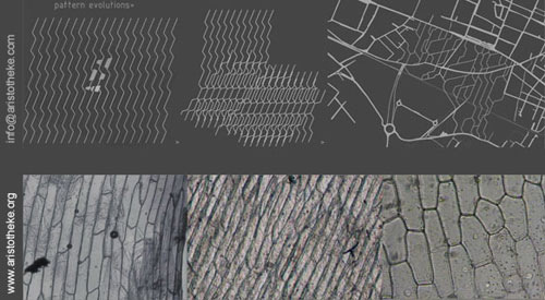
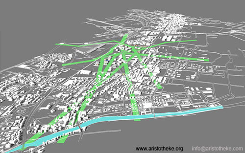
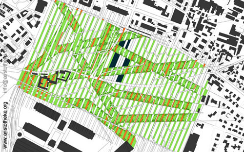
DIA-VERTICES: an independent formal system is introduced for the vehicular circulation network serving the proposed residential neighborhoods that anticipate further densification at later stages. The initial pattern is defined as a geometrical interplay of orthogonally segmented lines, with smoothed rounded corners, the dia-vertices, each of them translated into a one-way street. Batches of identical dia-vertices were composed together for a series of versions testing the visual and the functional premise of the generated vehicular circulation patterns. The in-between increment [distance], the module of re-positioning, the curvatures and the relational slide for each consecutive vertice reflects concerns for buildability of the adjacent lots [length of continuous linear portion], driving and turning radii [curvature of 90-degree turns], and the desired intensity of circulation [width of each string]. A specific number of roads will be materialized for each phase of growth making the formal system evident at the city scale. The densification of the built fabric on-site, in relation to the random interruption by the green bands, results to the definition of the maximum capacity street network.
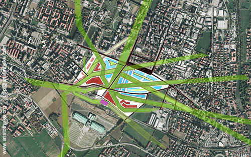
OFF-STREET LIVING: Central functional concern for the selection of the street network was the avoidance of long continuous streetscapes combined with the desire to maintain low-traffic speed creating a miniature parkway experience, and visually a vein-like flow chart pattern. All streets connect across the site, with no deadends. The project, at the pedestrian eye-level will be still defined by the linear landscape elements and not by the street system. This was a central concern, differentiating the project from the normative street-block layout and leading to the selection of a non-linear street pattern. The selection of the circulation pattern reinforces the visual primacy of the landscape components. Maximum operability is maintained at all stages.
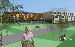
TYPOLOGIES: the building types were developed as new prototypes responding to variable stree-front qualities within the site. The urban edge at the north boundary invites taller mixed-use units, while the more residential sides generate a context fit for residential development.
QUASI-ROWHOUSE: raised two storied, fully independent units [detached] can be possibly interconnected, generating larger units. The narrow spacing of the units and the linear façade screens that blend the boundaries, along with the extended open ground floor piloti areas, generate a “lifted rowhouse” effect with numerous, varied voids and cross-connection slots. The facades feature variable projections and openings and the materiality of the streetfront screens is ustomizable. Street-side parking is combined with piloti on-ground parking, allowing for green and activity areas. The two-story cube, lifted on pilotis, accommodates singular units that can be further subdivided. Private rooms are on the top floor. The open-plan common areas are below.
RETAIL DISTRIBUTION: The location of urban nodes optimum for mixed-use growth is dictated through an analysis of traffic circulation and existing functions.
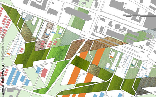
A major greenmarket is proposed, relating to the site's historical identity as the primary farmers’ market of the city of Bergamo. The rebuilt farmers market, emphasizing organic produce, becomes a primary public gathering area among the sites' various neighborhood public spaces and transit nodes.
The buildings, residential or other, become the infill material of the proposal. The presence of the built fabric adds vitality to the civic spaces, still, the parkland is planned to operate with no new housing also.
The haptic equation determining the programmatic allocation around the empty lots on the site, is based on adjacencies: the number of streets, bands or strips that line the edges of each series of lots prescribes its civic, commercial or residential focus.
CUBE-TAILED TYPE: common thread for all building typologies is the relation of enclosed space to semi-private green areas. For the quasi-rowhouse typology the open space is defined by the covered area of the piloti; the apartment block raises the green areas and assigns these onto floorslabs for each unit. The cube-tail typology responds to more commercial streetfronts while the opposite side gets absorbed by the greener inland territories. Parking and service zones are offered on the ground level, while the terraced slabs covering these zones become green tongues that invite common uses and offer topographic qualities to the flat terrain. These transformed linear utility spaces become the more introverted semi-independent territories for sports and arts events. The cube-tailed type is the most diverse typology addressing the complex boundaries of the new development towards the denser urban context around the road arteries.
Aristotelis Dimitrakopoulos
Related articles:
- HORROR VACUI: JOSTLE, HUDDLE AND HELLENIC MODERNITY ( 21 June, 2005 )
- ATTIC ECTOPIA ( 16 November, 2012 )
- FRONTAGE SHOWCASES AND THE POST-URBAN UNCANNY-A RECTROACTIVE MANIFESTO FOR HELLENIC PROFESSIONAL SPACES ( 01 January, 2010 )
- VI: Unrecycling Cyclades. Part 1 ( 04 October, 2010 )
- Gwangju Asian Cultural Center, Korea – International Competition Entry, October ( 7 December, 2007 )
- De-institutionalizing Education: Notes on Academic Initiatives(i) ( 7 July, 2007 )
- HARBORING CAR-BAN-ITIES [Port Nord Organizational Protocols] ( 8 October, 2007 )
- Stratifying Axialities> Celadina ReCelled (PART A) ( 14 March, 2008 )
- FRAGMENTARY IMPUNITIES > VALLADOLID TRAJECTORIES (PART A') ( 5 September, 2008 )
- FRAGMENTARY IMPUNITIES > VALLADOLID TRAJECTORIES (PART B') ( 5 November, 2008 )
- SUBTERRA * SUPRATERRA ( 22 May, 2009 )
- VI: Unrecycling Cyclades. Part 2 ( 14 October, 2010 )
- Translocality as a Post-Native Narrative ( 16 February, 2011 )
- Metaxekisis : Re-Thinking the Athenian Court ( 08 December, 2010 )
- L-I*-THEKE ( 02 April, 2013 )
- House - glyptotheque - gallery - workshop ( 19 July, 2013 )
- Piloting Pilotis ( 31 December, 2013 )
- Escalteca of the Choetheque Series ( 01 April, 2014 )
- Schottheke of the Choetheque Series ( 01 June, 2014 )
- Floatheca Rh of the Choetheque Series ( 01 August, 2014 )
- Floatheca Sp of the Choetheque Series ( 26 September, 2014 )
- O-theke of the Choetheque Series ( 11 March, 2015 )
- Floatheca Cy of the Choetheque Series ( 03 January, 2015 )
- Ophthalteca ( 24 June, 2015 )
- Y-theca of the Choetheque Series ( 08 October, 2015 )